
- Height: 1300 ft
- Distance: 11 miles
- Difficulty: Hard.
- Total Time: Allow about 4 hours. The terrain can be rough and muddy, making this a tiring walk.
- Navigation: The paths are clear and well-walked.
- Starting Point: Lay-by on the A832 near the fish-farm shop.
This walk takes you to Loch na Sealga and into the Letterewe and Fisherfield forests which lie behind An Teallach.
This is an uninhabited and inaccessible area containing 6 Munros, and the scenery is both wild and dramatic, with mountains rising up from both sides of the loch. Here is Sail Liath and access to An Teallach, and across the loch lie Beinn Dearg Mor and Beinn Dearg Beag.
This is a strenuous walk in a remote area, over often muddy and wet ground, so stout boots are essential.
Drive about two and a half miles out of Dundonnel towards the Braemore Junction on the A832, and park in a lay-by across from a rough but clear track leading up the hillside. The lay-by is near the fish-farm shop.
Cross the road and climb up the track, which follows the Allt Gleann Chaorachain and leads through a wooded area. The path leaves the trees and takes you through a wide, flat area with a waterfall. Cross the river and follow the path as it leads steeply up to the highest point of the path.
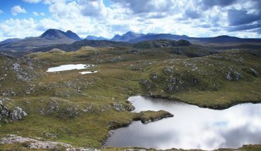
Loch na Sealga from the shoulder of Sail Liath.
Here the ground is open and rock-strewn, with a path leading straight ahead and another leading off to the left. Ignore the path leading to the left and follow the path going straight ahead, over the shoulder of Sail Liath and down to Shenevall. There is a bothy here. As the path descends and curves round the back of An Teallach, you get stunning views of Loch na Sealga and the mountains on the far shore. Here the scenery is greener and more fertile, and in summer the gorse bushes give a bright splash of yellow to the scene.

At the bottom of the path, turn left and head for the bothy at Shenevall. There is a rough track leading to the bothy and beyond, the path widening and becoming better as it joins another path and heads back up the hill to join the outward path.
Several words of warning if you intend to continue into the Fisherfield and Letterewe Forests to climb the Munros – there is no road access into this area, so there is no quick and easy exit if you have any problems. Let someone know where you are going and when you expect to return. Also, the river which feeds into Loch na Sealga, the Abhainn Srath na Sealga, has to be crossed to continue into the Fisherfield and Letterewe Forests. In normal weather conditions, this is a wide and deep river, about chest-height, and can only be traversed by wading across. When the river is in spate, the crossing is impossible. Furthermore, like other lochs surrounded by mountains, the water level can rise extremely rapidly in very wet weather. Take care and don’t underestimate the weather or the seriousness of walking in this area.

Map of walk from Corrie Hallie to Loch na Sealga, Gruinard River walk
and the walk to Loch Toll an Lochan.
Map Required:
- OS Landranger 19: Gairloch & Ullapool Area
Gruinard River
- Height: negligible
- Distance: 10 miles
- Difficulty: Moderate.
- Total Time: Allow about 3 hours.
- Navigation: The paths are broad and well-maintained. They allow vehicular access to the estate, so are in good condition.
- Public Transport: Bus between Ullapool and Gairloch. Get off near Gruinard Bay.
This is a walk along side the Gruinard River to Loch na Sealga. The path takes you through open countryside and woodland, until you reach a small shingle beach and boat house at the opposite end of Loch na Sealga from An Teallach. Here is a perfect place for a picnic and a rest before setting out on the journey back.
Drive on the A832 until you reach Gruinard Bay and a small bridge. The path starts on the right-hand side of the river. Park near here taking care not to cause an obstruction or block the entrance to the path as the path is used for vehicular access to the estate. The path itself is an excellent one, wide and well-maintained, following the course of the river as it meanders its way inland. The path crosses open countryside then climbs up to a wooded area, enclosed by deer fences. After leaving the trees, the path drops back down to the river, and crosses the river by way of a bridge instead of the old, extremely wet crossing by stepping stones.
The path ends here at a tiny shingle beach and the boat house. You are now standing at the opposite end of Loch na Sealga from Shenevall, and have views stretching up the loch towards An Teallach, Beinn Dearg Beag and Beinn Dearg Mor. Return by the outward route.
Map Required:
- OS Landranger 19: Gairloch & Ullapool Area

