
- Height: 1080 ft
- Distance: 8 miles
- Difficulty: Moderate to hard.
- Total Time: 3 hours
- Navigation: Clear path to the reservoir, but indistinct paths over rough open ground with some nagivation required.
- Starting Point: Cochno Farm (NS503740)
- Public Transport: Hardgate bus to junction with B8050, then walk to Cochno Farm.
A walk up a good path to a reservoir, then over rough open ground to Duncolm. Duncolm is the highest hill in the Kilpatrick Hills and offers superb views in all directions.
Despite their proximity to Glasgow and Dumbarton, the Kilpatrick Hills are actually quite remote, with few people about apart from occasional walkers and fishermen.
There are few clear paths, so a detailed map, preferably the Pathfinder NS 47/57 for Milngavie, is essential for navigation, as is a compass. The ground is often boggy and can be extremely wet, so stout, waterproof boots are essential, as is a spare pair of socks.
Drive on the A81 via Canniesburn Toll towards Bearsden, then take the A810 towards Hardgate. Just past the junction with the B8050 there are a series of electricity pylons. Turn up the minor road on the right and follow this to the sign for Cochno Farm. There is some open ground here suitable for parking (NS503740).
Walk back down the road and turn right, following the metalled road until you reach a filter station at a junction. Turn right again and follow the path as it gradually climbs up towards Greenside Reservoir. The path goes through a farm, which appears to be empty. The path now climbs up with a delightful stream and waterfalls on your left-hand side, until you reach a dam and Greenside Reservoir, a small reservoir popular with fishermen.
Keeping to the right-hand side of the loch, follow the narrow path round the side of the reservoir, climbing over fences, until you are on the opposite side of the loch. Unfortunately, the path is not always clear and the open moorland is riddled with tiny paths made by sheep. Head up and northwards until, reaching the brow of the hill, you can see Duncolm in the distance. A faint path should be visible, but if not, strike out in the direction of Duncolm and follow the path up to the summit and cairn.
Return by the outwards route, or walk back to Greenside Reservoir, but before reaching the reservoir, strike out to the left and head for Cochno Hill and Jaw Reservoir. Follow the path from the summit of Cochno Hill to the dam, taking care not to follow the lower path which is dangerous. From the dam head down the path with the river on your right-hand side. Go through a gate and head downwards, with woods on your right to a farm track with a stile. Continue and cross another stile, walking along a pipe track until you reach another stile and some woodland. Cross the stile and follow the track back to Cochno Farm.

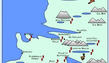
Map of walk to Duncolm via Greenside Reservoir,
with option return route via Cochno Hill and Jaw Reservoir.
This walk can be done in reverse, going to Jaw Reservoir and Cochno Hill first, then on to Duncolm. For a more detailed description of the section between Cochno Farm and Jaw Reservoir, see the walk below.
Map Required for both walks:
- OS Pathfinder NS 47/57: Milngavie
Duncolm and Kilmannan Reservoir
- Height: 1200 ft
- Distance: 13 miles
- Difficulty: Hard.
- Total Time: Allow about 5 hours for this walk. The lack of obvious paths and the difficulty of the terrain make this a very tiring walk.
- Navigation: A map and compass are necessary on this walk. The paths are unclear, and most of the walk is over rough open ground.
- Starting Point: Cochno Farm (NS503740)
- Public Transport: Hardgate bus to junction with B8050, then walk to Cochno Farm.
This is a strenuous walk in a remote part of the Kilpatrick Hills. The walk is mostly over open moorland with few paths, so a detailed map (OS Pathfinder NS 47/57 of Milngavie) and compass are essential. A few of the paths on this walk go through forestry land, but with new planting the paths constantly change, so you will have to navigate a route through the plantation. However, the paths are broad and can be clearly seen from an earlier part of the walk. This walk can be very wet, so take a spare pair of socks.
Park as for the walk to Duncolm via Greenside Reservoir (NS503740). This time, however, you are going to head straight for Jaw Reservoir. Enter Cochno Farm Road, the path to the right of the farm. This path leads round behind the farm building, passing through woods. About 100 yards along this path the trees begin to thin out and there is a gate on your right-hand side. Cross this and follow the path alongside the woods until you reach a stile. Cross the stile and follow the fence to the right. Cross another stile onto a farm track, then another stile which is part of a gate. Follow the farm track until you reach another stile. The path is now grassy and heading up towards woodland. Keeping the woodland on your left, follow the path up to a gate at the top of the hill, then head right and up the path beside the Jaw Burn. This path leads you to the dam at Jaw Reservoir (see photograph below).
Turn right and cross the dam of the reservoir. Go through a gate in the wall on your right and follow the faint track as it runs alongside the wall. The ground here is marshy and very wet, the path becoming indistinct. Keep heading downwards, following the path beside the wall until the wall turns left. Go through the gate and follow the path as it leads right. When a fence appears on your left, head out over the marshy ground towards the fence and follow it until a wall appears on your right. Follow the wall until it leads to a stream. Don’t cross this stream, instead follow it along to the left until you reach Kilmannan Reservoir and a metalled road.
Walk along the metalled road until you reach Burncrooks Reservoir. Keep to the left-hand shore-line of Burncrooks Reservoir, which is rocky with plenty of places to stop for lunch. You are now behind the Auchineden Hill and the Whangie, and from this part of Burncrooks Reservoir you can actually see the Whangie itself outlined against the sky. Rest here, with your feet in the cool water while taking in the scenery around you.
Map of walk to Duncolm via Kilmannan Reservoir.
Follow the shore-line of Burncrooks Reservoir until you reach a river on the opposite side of the reservoir from Auchineden Hill. Follow the river, climbing up as the river enters a deep gully. From here you should be able to see Duncolm quite clearly. The path is no longer visible, so you should strike out in the direction of a loch (Lily Loch) and Duncolm, taking care as the ground is very boggy. Beyond Lily Loch a faint path appears, which takes you behind Duncolm and up to the summit, but if you miss the path, a quick scramble up the grassy slopes presents no problems.
Return from Duncolm by heading south to Greenside Reservoir, down the path to the Filter Station and back to the car.

