
For a small country, Scotland has a remarkable diversity of rocks, fossils, landforms and soils. This geodiversity is the result of a rich and varied geological history, spanning some 3 billion years of the Earth’s existence. It forms an Earth heritage asset of national and international importance.
Scotland’s geodiversity illustrates a wonderful story of how colliding continents, ancient volcanoes, powerful glaciers and changing climates have shaped the landscape and scenery we value today; how different life-forms have evolved and how rivers, landslides, floods and sea-level changes are continuing to alter the land surface. Scotland’s rocks, fossils landforms and soils have played an important part in our understanding of the Earth. They also form the foundation upon which plants, animals and people live and interact.
Contents
What is geodiversity?
The term ‘geodiversity’ encapsulates the variety of rocks, minerals, fossils, landforms, sediments and soils in an area, together with natural processes, such as erosion and landslips, that may still be active.
Examples of Scotland’s geodiversity:
- Glasgow’s geodiversity includes drumlins – landforms produced with the passage of great ice sheets – upon which the city centre is built.
- Edinburgh’s Castle Rock, once a volcano, and the variety of building stone used in the construction of the New Town, are examples of the capital’s geodiversity.
- The thick peat soil that supports the biodiversity of the Flow Country, and the 380 million year old fossil fish in the bedrock of Caithness, are well known geodiversity features in the north of Scotland.
- The River Spey, that carries sand silt and other sediment eroded from the Grampian Mountains into the Moray Firth, is an example of Grampian’s dynamic geodiversity.
Many definitions of ‘geodiversity’ can be found in Britain and also the wider world, although the term is most commonly used in Europe and Australia. Definitions vary, but the majority are variations on: ‘Geodiversity is the variety of rocks, minerals, fossils, landforms, sediments and soils, together with the natural processes which form and alter them’.
Some definitions from the UK and Europe include a cultural aspect. For example the wording of the European Manifesto on Earth Heritage and Geodiversity starts: ‘Geodiversity links the Earth, its people and their culture’; and the often quoted article by Stanley (Welcome to the 21st century. Geodiversity Update, 2001, No. 1, p1): ‘So what is geodiversity? It is the link between people, landscape and their culture: it is the variety of geological environments, phenomena and processes that make those landscapes, rocks, minerals, fossils and soils which provide the framework for life on Earth’. This cultural aspect, while not included in the majority of definitions of geodiversity, reflects the important influence geodiversity has on society and culture.
Scotland’s rocks and minerals
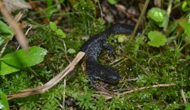
Fossils in Scotland
Fossils can be defined as the remains or traces of an ancient animal or plant preserved in rock. Scotland has a remarkable diversity of fossils stretching back over 1200 million years. Scottish fossils help us understand the evolution of life on Earth and the changing geographies and environments that existed throughout Scotlands long and varied geological history.
19th Century Scottish geologists such as Hugh Miller established basic geological principles using fossils from Scottish localities, and made them widely known to the general public. These fossil localities are of historical and cultural importance.
Scotland’s fossil heritage is an important scientific, economic, educational and leisure resource that has a wide range of users including research scientists, students, school pupils, amateur and commercial collectors and the general public.
If collecting fossils in Scotland, please do so responsibly and follow the advice on best practice in the collection and storage of fossil specimens outlined in the Scottish Fossil Code.
For more information on fossils in Scotland including Classic Sites for fossils, and famous fossil collectors, visit the scottishgeology.com website.
Scotland’s Ice Age landforms
Coasts around Scotland
Scottish Rivers
Scottish rivers and burns can be truly wild! Even in our cities where they may be constrained by artificial beds and banks they are a reminder of the power of natural forces, sometimes disrupting our lives through hazardous processes, like bank erosion and flooding. These pages give some examples of the different types of rivers and burns found across Scotland.

Where our rivers run
The geological history of Scotland has shaped our river landscapes. Seen from above, on satellite images, Scotland has a watershed that runs down from the north of Scotland, close to the west coast. From here we have short steeper rivers descending the mountains of the west coast, and longer and larger rivers draining the eastern side of this watershed.
This current drainage pattern with short steep rivers to the west and longer rivers flowing east, first originated late in the Palaeogene geological period (65-23 million years ago). Volcanic activity, in the Palaeogene, associated with the opening of the north Atlantic also resulted in large volumes of molten rock cooling underground in a process known as underplating. This caused rapid uplift of many parts the Highlands by as much as 1 km. In general areas to the west, nearest the centre of the volcanic activity, were elevated higher than those tote east. This resulted in a broad overall pattern of land raised highest in the west and sloping away gently to the east.
Since the end of the Palaeogene, erosion by rivers, wind and also glaciers during the Ice Age, have cut steep west-flowing watercourses into the uplifted western sea-board. Water and ice flowing east, in contrast, have continued to descend down the shallower gradients towards the North Sea.
How rivers and burns work
Most Scottish Rivers are dynamic, sometimes causing serious hazards. Yet this mobile nature is the way that rivers work, responding to local climate, weather events (like heavy rainfall), landscape and different types of land use.
A rivers “work” is to transport sediment and water. Moving water can only transport sediment when there is sufficient force to overcome the strength of the sediment. Smaller lighter grains of clay and silt can be carried in suspension by moderate flows of river. But in general bigger sizes of sediment require stronger river flows to move them, which means the river needs to be sufficiently deep and fast flowing, which may only occur a couple of times a year during a flood. The larger sediments (coarse sands, gravels, cobbles and boulders) are moved by the flowing flood waters by bouncing and rolling the stones along the river bed.
Different parts of the channel experience different levels of erosion (removal and transport of sediment), and deposition (dropping of transported sediment). Erosion is the dominant process in steep and deep parts of the river, such as the outside of river bends and in deep scoured pools. Sediment is deposited in swallowing water, and where a river channel widens. Depositional landforms include gravel and sand bars, and shallows that cross the channel diagonally between pools, called riffles. During floods rivers can drop fine sands, clays and silts across inundated floodplains.
This river work creates different types of river character.
Scottish river types
There is a great variety of river types found across Scotland, from short steep boulder bed burns in the mountains, to the wide tidal firths (estuaries) of the bigger rivers. These provide Scotland with a great diversity of river habitats and landscapes.
Different types of river include:
- Rivers descending the mountains
- Rivers in straths and glens
- Rivers crossing the lowlands
- Rivers flowing into the sea.
Landslides in Scotland
Moving fast or slow, ranging from truly huge rock face collapses to microscopic movement of soil particles, landslides (also called mass movements) are evidence of slope readjustment to gravity. Scotland has a great variety of examples of land slides such as rock falls, rock slope failures, rotational land slides, translational slides, debris flows, mud flows, solifluction, and soil creep. They range in size from spectacular whole mountain side rock slope failures such as seen on ‘Beinn Fhada, Kintail, to really small scale features that move imperceptibly such as soil creep, that can create rumples on grassy slopes.
Causes of landslides
What ever the scale, landslides occur when the forces for movement (gravity) overcomes the strength of the hill slope itself. In progressive slope failures such as soil creep and even large scale rock slope failures, movement may be intermittent over very long time periods, but can be enhanced by changes in environmental conditions, especially changes in water flow within soil and rock.
In Scotland single event slope failures, such as debris flows and rock falls, are closely associated with weather conditions, such as freeze thaw cycles or prolonged or intense rainfall. Water or ice crystals reduce the internal strength of the rock or soil by prizing rough surfaces apart, and allowing movement along gaps or smoother surfaces.
The time before a landslide occurs is just as important as the trigger event.
- Weathering along fissures in the rock face will reduce the strength of the rock, so that it is susceptible to failure, requiring only a trigger mechanism to overload the slope and make it fail.
- Availability of susceptible rock or sediment.
- Changes in vegetation cover also affects the ability of the slopes to remain intact.
Different types of landslides
Landslides are a group of land forms created by the down slope movement of a mass of rock or soil due to gravity. They have been classified in many ways, but can be grouped by scale, where they occur, whether they are caused by one off events or long term movement, and by the dominant type processes of movement (falls, topples, slide, spread, flow and creep). Individual landslides are usually formed by one or more of these processes, consequently classifying distinct groups of landslides has proved challenging! Here we have grouped the different types of features according to where they occur, whether they predominantly involve bed rock, or regolith, weathered rock, soil and superficial deposits such as glacial tills.
Landslides in rock
Rock Falls

Single and small rock falls from cliffs accumulate to form aprons of scree or talus, developing sometimes over long time periods. Some scree slopes are relict, where the scree apron almost buries the crags that once released rock falls that formed them. A characteristic of actively forming rock fall screes is the sorting of rock debris, with largest stones at the base of the scree, and smallest at the top. This sorting gets disrupted by reworking of the scree slopes by other processes, such as snow avalanching, debris flows and gully erosion by water.
Rock Slope Failures

Rock slope failures are a group of landslides that show great variation in their features. Many in Scotland are so large (involving whole mountainsides) that many people do not even see them! For example the rock slope failure on Beinn Fhada in Kintail is huge – 3 km long, from near sea-level to 1000m, and possibly over 100 million cubic metres in failed mass.
Rotational Landslides
In Scotland there are excellent examples at Trotternish in Skye and at Hallaig in Raasay, where multiple failures have produced spectacular whole mountainside collapse. In the case of Hallaig the landslide complex continues under water down to the sea bed.
Landslides in rock and soil debris
This page looks at the range of types of landform created by the movement of weathered rock, till and soil due to gravity. Many landslides occur due to sudden rainstorms, prolonged very wet conditions, and snowmelt. However, unstable slopes?can also be caused by the melting of frozen ground on?Scotland’s mountains.?Landslide movement?can be?sudden (especially those caused by intense rainstorms) or it may be so slow?that we hardly notice, except for a few tell tale signs like cracks in the ground, and subsidence on affected roads.?
All landslides are potential hazards, but most occur in remote mountain areas away from people. Debris flows in particular are a regular hazard that disrupts transport routes in the Highlands during severe weather conditions.
Creep
Creep is the slow downslope movement of material under gravity. It generally occurs over large areas. Three different types of creep are recognised: Seasonal movement or creep within the?soil, due to seasonal changes in soil moisture and temperature (for example frost heave processes). Continuous creep where soil and rock debris is not strong enough to resist gravity. Progressive creep where the soil and rock debris suddenly reaches a critical state where it will fail due to other factors.
Solifluction
Solifluction sheets and lobes are found on steeper slopes, where the loosened boulders and soil have been moved downslope by ‘solifluction’ (a mixture of soil creep and flow) processes, forming distinctive sheets, terraces and lobes of debris and boulders. Larger boulder lobes in Scotland were last active during the Loch Lomond Readvance (12,900 – 11,500 years ago), but some smaller solifluction features are active most winters.
Translational slides
These types of slumps and slides occur?during very wet weather, when the near surface soil and rock debris becomes saturated?with water, and slides and flows off downslope. They can develop into more dangerous debris flows on steep ground, where the landslide may travel a long distance churning up the debris into a slurry.
Debris flows
Debris flows are?Scotland’s most common type of landslide hazard. They range in character from sloppy wet mud flows to a mixture containing more rock debris and?similar in consistency?with a slurry of wet concrete. They ?occur on steep slopes,?greater than 20?, and once started?can continue to?travel over?much gentler ground where slopes?may be only?10?. How far a debris flow travels?depending on the mix of debris to water being churned about. Many debris flows start off as translational slides, but as the slide moves down slope the water and rubble gets mixed up and forming a slurry?that can?flow. Debris flows often leave a trail of abandoned rubble in their wake, forming distinctive ridges or levees.
Debris flows range in size from 1 to 10 metres across, carrying 1 to several cubic metres of debris. Debris flows may occur as one offs from open hillsides, but repeated debris flows are more common below gullies.
Debris cones form where repeated debris flows accumulate, usually beneath gullies. Many debris cones in the Highlands have periods of activity and quiet, depending not just on suitable weather conditions needed to trigger them, but also on the availability of mud and rock collected higher up in the gully floor.
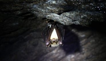
Caves and karst in Scotland
Karst may be defined as a distinctive landscape created by erosion of a soluble rock where the topography and landforms are a consequence of efficient underground drainage.
Going underground
The characteristic features of karst therefore include disrupted surface drainage (e.g. streams that vanish underground), dry valleys and caves. Limestone, and to a lesser extent dolomite (magnesium-rich limestone) are the most common rocks that are sufficiently soluble in natural surface waters to form karst.
Karst is a very minor component of Scotland’s landscape. Only in Assynt do solution features (in Durness dolomite) occur on a scale where they create distinctive landforms. These include karst and caves in the Trail gill and Allt nan Uamh valleys, and caves near Knockan and on the Achmore plateau.
Pre-glacial karst features were largely removed by Scotland’s last glaciers; so karst features mostly post-date the end of the glaciation, around 11,500 years ago. However, many cave passages pre-date the last glaciation, which peaked around 22,000 years ago.
The Durness dolomite extends both north and south of Assynt from Smoo Cave on the north coast, to small caves near Loch Slapin on Skye and others around Kishorn. There are also caves and limestone pavements in Glen Creran.
Thin Jurassic limestones contain small caves around Broadford on Skye, and also the cave passages of Uamh nan Breagaire at Applecross. Small caves also occur in Dalradian marble (heated and compressed limestone) near Schiehallion, and at Uamh nan Uachdar in the Grampians south of Glen Spean. There are no records of caves in the limestones of the Midland valley.
Wave action
Some caves are cut into rocks that are neither limestone or dolomite. These features lie along ancient raised shorelines and were cut largely by wave action when they lay at sea-level. In many cases this was probably shortly after the last period of glaciation (ice cover) in Scotland, during and just after the ice melt. Well-known examples include Fingal’s Cave on Staffa, cut into a ~65 million year-old columnar-jointed lava flow; and King’s Cave on Arran, cut into ~250 million year-old New Red Sandstones.
Scotland’s Soils
Soils are one of Scotland’s greatest assets, and are at the heart of all terrestrial life. Soils are a complex mixture of mineral, organic and inorganic compounds, living organisms, air and water. Soil depth varies from only a few centimetres in mountain soils to several metres in deep peat soils. However, soils are more than the simple sum of their physical, biological and chemical features; they are a vital, active interface between biodiversity, geodiversity, the atmosphere and water and the human environment. Soils are, therefore, recognised as a vital part of our economy, environment and heritage, to be safeguarded for existing and future generations.
Soils – the living skin of the Earth
Although we tend to refer to “the soil”, there is in fact a huge diversity of soil types in Scotland. Unlike plants and animals, soils do not exist as distinct types but form a continuous and always evolving pattern over the land surface. Find out more in our Soils booklet from the Scotland’s Living Landscapes series.
How does soil form?
Where there is terrestrial life, soils will form, even in the remote areas like Antarctica. Soils in Scotland are relatively new as, after the retreat of the Ice Age glaciers (around 11,500 years ago), most of Scotland was bare of any soil or vegetation cover. Soils develop by input from both the surface (accumulation of dead vegetation, erosion deposit) and underground (alteration and chemical weathering of the underlying geological material).
Soil types are determined by the nature of the underlying geology, their position in the landscape, climatic factors, plant and organism activities. (soil forming factors ). Human activity has also left an indelible imprint on soils over century and pristine soils are very rare in Scotland.
This combination of factors created variety of soil properties which means that soils not exist as distinct types but form a continuous and always evolving pattern external site over the land surface.
Soil properties
Soils represent a dynamic part of our natural environment with many inter-linked chemical, physical and biological processes acting either together or consecutively to create a distinctive soil profile. Well structured soils have a good balance of clay, silt and sand particles, organic matter and pores spaces to ensure good drainage and aeration.
Soil properties determine the role and values of soil in supporting a range of ecosystem good and services which are essential to human life and well-being.
Soil Forming factor
Climate
- At low temperatures, the rate of soil formation is slower. This is because the organisms that break down and incorporate dead matter are less active. Precipitation (rain, snow, mist) influences both chemical and physical breakdown of parent material. Rain water is very important in washing organic matter another substances down through the soil.
Landscape
- The shape of the land controls factors such as soil depth and drainage. On slopes, soils tend to be thinner and material move downslope. Deeper soils are found on valley floors and in hollows. Altitude acts together with temperature to influence rate of soil development.
Vegetation
- Different plants are made up of many different chemical compounds. When the plants die and decay, these are released into the soil. The physical action of plant roots and earthworms pushing through the soil is also important.
Organisms
- Micro-organisms are essential to a healthy soil. They break down and incorporate dead plants and animals, eventually forming a black, crumbly substance called humus. Larger creatures, like moles and earthworms, help to improve soil structure.
Geology
- Usually, the chemical composition of the soil is very similar to the parent material it develops on. Few soils in Scotland have formed directly from underlying rocks. At the end of the last period of Ice cover (around 11,500 years ago), the retreating glaciers deposited a layer of material over the original land surface. It is this material – known as glacial till – that forms the basis for most Scottish soils.
Time
- Scottish soils are quite ‘young’, being at most around 11,500 years old. In other parts of the world, like the tropics where soil formation has not been interrupted by glaciation, the soils are often far older – millions of years in some cases – and deeper.
The main soil types in Scotland
In Scotland, all the soils we see today have formed since the last glaciers melted around 11,500 years ago. The ever-evolving nature of soils, however, means that they are being continually formed and modified both by natural processes and by human activities.
These interactions are responsible for the wide range of soils that exist in Scotland today. Due to Scottish colder and wetter climate, our soils are in general more organic, wetter and more leached, than soils elsewhere in the UK and Europe.
A unique soil classification system has been developed for Scottish soil . Four major soil types account for nearly 90% of land coverage .
- Peats are soil with a deep (> 50 cm) layer of organic matter. They form under high rainfall or permanently waterlogged conditions, where vegetation slowly decays and accumulates at the surface. Accounting for around 11% of the land area, peat nonetheless holds over 70% of all soil carbon in Scotland.
- Gley soils are also poorly drained but without accumulation of organic matter. They cover around 34% of Scotland.
- Brown forest soils are well drained and are often deep fertile soils favourable for agriculture. They represent around 15%.
- Podzols develop on acid and freely drained material where nutrients can be leached out making it less suitable for agricultural use. Podzol accounts for around 27% of Scotland land areas.
- Montane soils On the more exposed mountain top, soil formation is very slow, therefore soil are usually very shallow. Such soil are very easily damage (e.g. erosion or pollution) and unlikely to recover naturally. Such soils represent around 6% of Scotland.
Three billion years of Earth history
Scotland’s oldest rocks formed some 3 billion (3,000 million) year ago which is a very long time ago! Comprehending the immensity of the time it has taken for Scotland to form – the immensity of geological time – is not easy.
A brief history of geology
The first person to suggest how vast a stretch of time we have to comprehend, was Scottish gentleman farmer and geologist James Hutton (1726-1797). Hutton realised that several cycles of sediment deposition; burial; heating, compression and folding; and re-exposure through erosion, must have occurred to account for the rocks formations he observed in Scotland. He also realised that these cycles would each take thousands or even millions of years. His studies lead to the observation that there is ‘no vestige of a beginning, no prospect of an end’ to the processes which formed rocks in the past and are still forming them today.
Eons, epochs and ages
These days, radio-isotope dating has allowed us to begin to quantify the depths of geological time, and the internationally agreed geological timescale allows us to correlate rocks and geological events world-wide. The timescale divides geological time into Periods and also larger divisions (Eras and Eons) and sub-divisions of time-Periods (Epochs and Ages). The current geological Period, the Quaternary, began 2.6 million years ago with the start of the most recent Ice Age. In contrast, the well-known Jurassic Period (‘Age of the Dinosaurs’) spanned a much larger time than the current Quaternary, lasting from 200 million years ago to 145 million years ago. Other geological periods are similarly of various different lengths, their starts and ends defined by factors such as global or regional change in environment or mass extinction events.
Fossil records
One very important geological boundary is that at the start of the Cambrian period (542 million years ago). This is the point, in the geological record, where life-forms with hard body-parts (e.g. shells) first appear. As hard body-parts, unlike soft ones, preserve well as fossils, this is the point at which our main fossil record begins. Because we get a lot of our information about past environments and geological time from fossils, the start of the Cambrian period is defined as the start of the Phanerozoic Eon or ‘Known Time’. Geological time before the Cambrian period is often referred to simply as the Precambrian.
Hutton leading the way
Hutton’s observations and theories marked the birth of the science of modern geology. They paved the way for later geologists to unravel the breathtaking tale of how Scotland has been 3 billion (3,000 million) years in the making. Study of the Earth as it is today, with its volcanoes and glaciers has been key in understanding Scotland’s 3 billion year history. However, the truly ancient history of our country, the evidence for which is all around us, is crucial in helping us to understand our world today and predict how it will change tomorrow.

