- Height: negligible
- Distance: 3 miles
- Difficulty: Very easy
- Total Time: at least one hour
- Navigation: Good clear paths round the park. Maps available at the Visitors’ Centre.
- Facilities: Tea-room and toilets at the Visitors’ Centre.
- Starting Point: Any one of the car parks in Mugdock Country Park.
- Public Transport: A bus runs from Glasgow to Mugdockbank (300yds from the South Lodge car park). Details from GCT (0141-636 3043). A train runs from Glasgow Queen Street to Milngavie Station Monday to Saturday.
This is an easy and popular walk through parkland on a series of good paths. This walk can also be extended by walking to Carbeth Loch on part of the West Highland Way.
Start this walk from one of the many car parks giving access to Mugdock Country Park – drive to Milngavie, then turn up Ellangowan Road across from Tesco and Kwik Fit, following this road towards Mugdock Village.
There is a car park up the hill after you pass the Reservoir (another good walk), or you can continue through Mugdock Village, turning left at the cross roads and continuing to the Craigend Visitors’ Centre, where there is a tea-room, toilets, an adventure playground and children’s playground, and a small information centre.
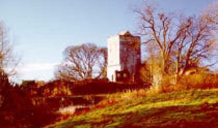
A walk through Mugdock Country Park offers a variety of scenery ranging from ruined castles and lochs to wooded areas and open fields, all on good paths. The ruined castle, Mugdock Castle, which is in the process of being renovated, dates back to 1372, though little remains now apart from a high stone wall, the South-West tower and walled gardens. There is also a ruined mansion house, Craigend Castle, at the other end of the park.


The South-West tower of Mugdock Castle (left)
and the ruined mansion house, Craigend Castle (right).
The park is a haven for birds, and this is a good place to see cygnets, ducklings and goslings in the spring. There are two lochs, a large one at Mugdock Castle and a smaller one at the Visitors’ Centre. Special islands have been created so that the birds can breed undisturbed by the many visitors to the park.

Swans and cygnets at Mugdock Loch.

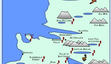
Map of Mugdock Country Park
Maps Required:
- OS Landranger 64: Glasgow & Surrounding Area
- OS Pathfinder NS 47/57: Milngavie
Carbeth Loch
- Height: 100 ft
- Distance: 6 miles
- Difficulty: Moderate
- Time: Allow at least one hour
- Navigation: The paths are clear and well-walked.
- Starting Point: Any one of the car parks in Mugdock Country Park, or this walk can be started at the West Highland Way starting point in the Milngavie shopping precinct.
- Public Transport: A bus runs from Glasgow to Mugdockbank (300yds from the South Lodge car park). Details from GCT (0141-636 3043). A train runs from Glasgow Queen Street to Milngavie Station Monday to Saturday.
This is a circular walk from Mugdock Country Park to Carbeth Loch on part of the West Highland Way. If you plan to park your car at the Kyber Car Park, remember that it closes at 4 pm, even in the summer months. There is also a notice at the start of the section of the West Highland Way that no bikes are allowed.
The walk round Mugdock Country Park can be extended to include a small part of the West Highland Way. You can start this walk from two different points: the West Highland Way starting point in Milngavie shopping precinct, or you can park your car at the South Lodge Car Park, just beyond Mugdock Reservoir (or take the bus to Mugdockbank).
If starting in Milngavie shopping precinct, follow the signs for the West Highland Way. If starting the walk from Mugdock park, leave the South Lodge Car park, go through the gate and take the path to your left which leads up over the moor to Mugdock Castle. When you reach the castle, turn left and follow the footpath signposted for Mugdock Wood and Drumclog Moor. This path leads down into Mugdock Wood where the path joins up with the West Highland Way. This is a delightful part of the walk, a well-maintained path leading through an environmentally sensitive area of woodland filled with bluebells, lush grass and mature trees. There is plenty of wildlife here, from birds to roe deer.
Part of the walk is on a wooden-slatted platform, which can be slippy during and after rain, so take care here. When the path reaches a ruined cottage, take the path for Drumclog Moor and follow this path until it joins the West Highland Way. The path now levels out until it reaches a road. Cross the road and head downhill until you reach a gate and signpost for the West Highland Way on your right. This is a good path, following a stream to Craigallion Loch and some forestry plantations until it reaches a gate. The path now turns right and heads down towards the wooden holiday homes at Carbeth Loch.
As you pass the last wooden holiday home, turn off the West Highland Way and cross the stile to your right (signposted Public Footpath), following a path which gently climbs up through a forest. Follow this path until you reach a signpost and the public footpath which runs from Mugdock Country Park to Braehead on the B821. Turn right onto the public footpath and follow it until you reach a fork in the path. Take the narrow left-hand path (signposted Public Footpath) and follow it as it leads through some trees before reaching a stile and the road. Cross the stile, turn right and climb up the road until you reach the Kyber Car Park again. Walk back through Mugdock Country Park until you reach the South Lodge carpark.

Map of walk round Craigallian Loch.
Maps Required:
- OS Landranger 64: Glasgow & Surrounding Area
- OS Pathfinder NS 47/57: Milngavie

