
- Height: 2800 ft
- Distance: 13 miles
- Difficulty: Hard.
- Total Time: Allow at least 5 – 6 hours, probably longer since the climb is very steep and tiring.
- Navigation: The paths are sometimes clear, sometimes indistinct, and the terrain can be rough.
This is a long and strenuous walk on clear paths into a wild and remote part of Sutherland. The climb to the bealach on Suilven is a hard, steep climb, but the rest of the walk is easy if tiring. Allow plenty of time for this walk.
There can be restrictions on this walk during the stalking season, so check with the local Tourist Office in Lochinver or Ullapool.
Drive to Inverkirkaig, where there is an excellent tea-room and book/gift shop. Go through the gate and follow the path to the Kirkaig Waterfalls on good fishermen’s and stalkers’ paths.
The Kirkaig Falls are considered to be among the finest waterfalls in Scotland and, unlike Eas Coul Aulinn, there is always plenty of water in the falls as a series of lochs drain out through the Kirkaig River.

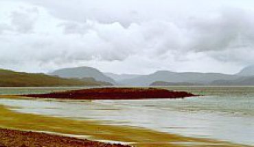
The Kirkaig Falls (left), and your first view
of Suilven from the Inverkirkaig Path (right).
Walking further along the path you get excellent views of Suilven. Continue along the well-defined and sometimes boggy path, which winds its way round Fionn Loch before heading inland for Suilven. The path up Suilven is very steep, leading up to the narrow bealach and a stone wall! From here it is a much easier climb up to the summit at Casteal Liath. The summit itself is a wide, flattish summit with stunning views in all directions. The summits at the eastern end of Suilven can also be visited, but they involve exposed scrambling and are for experienced climbers only.

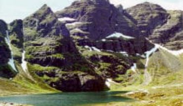
View, looking north to Quinaig,
from near the summit of Suilven.

Map of walk to Suilven from Inverkirkaig.
Map Required:
- OS Landranger 15: Loch Assynt & Surrounding Area
Stac Pollaidh
- Height: 1800 ft
- Distance: 1.5 miles
- Difficulty: Moderate to Hard.
- Total Time: Allow about 2 hours.
- Navigation: The paths are well-walked and clear, but the terrain can be wet, muddy and rough.
This is an easy walk up one of Scotland’s most popular mountains. Stac Pollaidh is a small mountain with stunning views out over the Inverpolly Nature Reserve and excellent views of Suilven. The summit is actually on the west side of the mountain, but the rocky spires and outcrops are crumbling and dangerous, requiring some climbing experience and a head for heights!
Drive north from Ullapool on the A835, then turn into the Inverpolly Nature Reserve and take the road for Achiltibuie, parking in the car park at the base of Stac Pollaidh. Cross the road and head up the rocky and well-defined path which looks as though it is heading right up the front of Stac Pollaidh, but then veers off steeply to the right. Once off the rocky path, the going can be muddy and wet, but when you reach the back of Stac Pollaidh the ground becomes rockier again. From here you can either take one of the short but steep scrambles up to the narrow ridge, or head along towards the west side of Stac Pollaidh from where there is a longer but less steep path. From the ridge there are stunning views north to Suilven, Canisp and Quinag, west to the Summer Isles, south to Ben More Coigach and inland to the east.

Stac Pollaidh from the road (left),
and a view from the summit of Stac Pollaidh (right)

View of Stac Pollaidh from the car park.

Map Required:
- OS Landranger 15: Loch Assynt & Surrounding Area

