
- Height: negligible
- Distance: 1 mile
- Difficulty: Easy
- Time: Allow about 20 minutes.
- Navigation: The path to the waterfall is clear and well-walked.
- Starting Point: Car park for Bracklinn Falls at (NN639084).
- Public Transport: Public transport by bus to Callander, followed by a short walk to the start of the walk to the Bracklinn Falls.

This is a lovely walk on good paths to a narrow bridge and spectacular waterfalls. This walk can be extended into a circular route which follows the Keltie Water.
Drive to Callander on the A81 or the B822 via Fintry, turn right into the high street and take a left turn into a minor road, following signs for the Bracklinn Falls and Golf Course. Continue past the Golf Course Visitors’ Car Park and head up a very narrow road until you see a parking area and signpost for the Bracklinn Falls (NN639084).
Go down the steps from the car park and follow the well-defined path through meadows filled with wild flowers, and natural woodland of alders and rowan trees.

The path narrows as it reaches the Bracklinn Falls, and descends via a series of steep steps to the narrow bridge spanning the Falls. Cross the bridge and take in the views of the Falls from the rocky outcrops, taking care as the ground can be muddy and slippy. When the river is in spate, the Bracklinn Falls are spectacular.

Bracklinn Falls

Map of walk to Callander Crags, Bracklinn Falls and walk along the Keltie Water.
Walk along the Keltie Water
- Height: 150 ft
- Distance: 4 miles
- Difficulty: Moderate
- Time: Allow about 90 minutes.
- Navigation: This walk is on clear paths.
- Starting Point: Car park for Bracklinn Falls at (NN639084).
- Public Transport: Public transport by bus to Callander, followed by a short walk to the start of the walk to the Bracklinn Falls.
Walk to the Bracklinn Falls, cross the bridge, then head up to a fence at the edge of the woodland. Turning right, follow a very narrow but clear path which runs alongside the fence. This path leads along the top edge of the gorge – take care on this path and don’t be tempted to lean over too far to see the river below – it’s a long way down! The path eventually crosses the fence and takes you out onto farmland, from where you should be able to see farm buildings. Strike out over the farmland, heading up to the top of the small hill directly ahead of you – from here you should be able to see a gate and a clear track higher up, leading back the way you have just come. This track is a farm/forestry track, which climbs steadily upwards through forestry land high above the Keltie Water. Once the path reaches the highest point, a steep path leads up to the right, which you should ignore – your path is the wider of the two, which now heads back down towards the Keltie Water. Through the trees you can now see the road.

At the bottom of the track there is a wooden bridge which crosses the Keltie Water, and a narrow path which leads off to the left, along the river bank. Follow the narrow path along the side of the river – the waterfalls here are quite delightful! The path then descends very steeply, taking you down to a local beauty spot with a deep pool and waterfall.
Climb back up the path and head back to the bridge. The forestry road now joins the narrow road where you parked to walk to the Bracklinn Falls. Walk back along this road to the car, or you turn off at the sign for the Crags and head up the top of the Callander Crags.

Callander Crags
- Height: 890 ft
- Distance: 4 miles
- Difficulty: Moderate to hard.
- Time: Allow about 2 hours.
- Navigation: The paths are clear and well-walked.
- Starting Point: Car park for Bracklinn Falls at (NN639084).
- Public Transport: Public transport by bus to Callander, followed by a short walk to the start of the walk to the Bracklinn Falls.
This is quite a strenuous climb through woodland to the crags high above Callander. From the top, the views of Callander, Loch Venachar and the surrounding landscape are quite stunning. Take care on the higher parts of the Crags, and be extra careful where there are exposed tree roots, which can be very slippy if there has been a lot of rain.
Drive to Callander as for the walk to the Bracklinn Falls, turn left into the high street and park in the large car park on the right-hand side of the road (NN623082), or park beside the nearby tennis courts. Follow the Forestry Commission sign posts for the Crags.
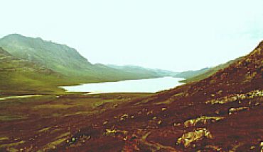
The path follows a ruined wall and deer fence as it heads steeply upwards, lined by large beech trees and conifers. Cross a stream and keep climbing until the path levels out to give you your first views of the surrounding countryside. Keep walking until you reach the cairn from where you should, on a good day, be able to see Ben Vorlich to the north, the Ochils, Stirling Castle, Ben Venue and Ben Ledi.

View from the Crags high above Callander.
You are now on moorland with no clear paths. However, the road is clearly visible to your right, and you should make your way carefully over the rough ground towards a signpost for the Crags. Follow this road back towards Callander and the Bracklinn Falls. Walk back through Callander to the car park.
This walk can be done in reverse, first visiting the Bracklinn Falls, then walking up the road from the Falls to the signpost for the Crags. This is a more gradual ascent, and some people may find this easier than the sharp, steep ascent from the centre of Callander.
Map Required:
- OS Landranger 57: Stirling and the Trossachs area.


