
Callander is the perfect location for exploring the Trossachs. Callander itself has some delightful walks, including Ben A’an, Callander Crags and Bracklinn Falls, while it offers easy access to Loch Katrine, the Queen Elizabeth Forest Park, Lochearnhead, Strathyre and Balquhidder. This is an excellent area for walkers, with a variety of lower-level walks, forestry walks and spectacular mountains. Cyclists too are well-catered for, with plenty of cycle paths.
Walks:
Easy:
- Bracklinn Falls, height negligible, 1 mile: A lovely walk on good paths to a narrow bridge and spectacular waterfalls. Public transport to Callander, then a short walk to the start of this walk.
Moderate:
- Keltie Water, 150 ft, 4 miles: An extension to the walk to the Bracklinn Falls, walking along the Keltie Water to a local beauty spot. Public transport to Callander, then a short walk to the start of this walk.
Moderate to Hard:
- Ben A’an, 1300 ft, 4 miles: A short and very steep climb to the summit of a mountain overlooking Loch Katrine. Despite its size, the views from the summit are spectacular. No public transport as far as I know.
- Callander Crags, 890 ft, 4 miles: A steep and strenuous walk up to the crags high above Callander. Public transport to Callander, then a short walk to the start of this walk.

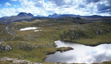
Loch Lubnaig, north of Callander
Public Transport
All walks, except Ben A’an, are within walking distance of the centre of Callander.
Buses:
Post Bus Services: There are post bus services serving Aberfoyle, Brig o’Turk, Inversnaid, Strathyre and Lochearnhead. Contact Callander Post Office for times (Telephone: 01877 330267).
Cycling
This area has some excellent facilities for cyclists, including the cycle path from Callander to Strathyre, the cycle path from Drymen to Callander via Aberfoyle, and cycle trails in the Queen Elizabeth Forest Park. Cycle hire is available at the Queen Elizabeth Forest Park, which provides off-road cycle trails between 3 – 15 miles in length (Telephone: 018772 383). There is a leaflet called Cycling in Scotland available from the Scottish Tourist Board, 23 Ravelston Terrace, Edinburgh ED4 3EE.
Maps
| OS Landranger 1:50,000 | OS Outdoor Leisure Maps 1:25,000 |
| No 57: Stirling and The Trossachs Area | No 39: Loch Lomond |
Further Information
- Walk Loch Lomond and the Trossachs by Gilbert Summers, published by Bartholomew.
- The Munros by the Scottish Mountaineering Club.
- The Corbetts and Lesser Hills by the Scottish Mountaineering Club.
- 100 Best Routes on Scottish Mountains by Ralph Storer, published by Sphere.
- Walking in the Trossachs by Rennie Mcowan, published by The Saint Andrew Press.
- 25 Walks in the Trossachs by Cameron McNeish, published by HMSO.
- The Glens of Trossach: A Guide for Walkers and Mountainbikers by Peter D. Koch-Osborne, published by Cicerone Press.
Accommodation, Restaurants and Information on Callander
- LenyMede B&B, Callander
- Sherry’s Restaurant

