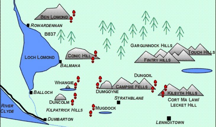
The north of Glasgow is an ideal area for walking and hillwalking. It offers quick and easy access to a wide variety of walks, ranging from Ben Lomond, Scotland’s most southerly Munro, to Mugdock Country Park with its ruined castle; the extinct volcanic plug, Dumgoyne, at the end of the Campsies; the geological fault at the Whangie and Queen’s View; the Kilpatrick Hills and the Arrochar Alps – all within a 60-minute journey by car from the city centre.
These pages are a collection of favourite walks from the north of Glasgow. We hope these pages will be of interest to people living in or near Glasgow and to people planning to visit Glasgow – all too often people visiting Glasgow expect this to be a city-only visit, but with such beautiful countryside only 30 – 60 minutes away, nothing could be further from the truth. Glasgow is quite a compact city, and getting out to the countryside is quick and easy, as I hope these pages demonstrate.

Walks
Easy:
- Carbeth/Burncrooks Reservoir, height negligible, 5 miles: An easy walk along good paths to a reservoir in the Kilpatrick Hills. Public transport to start of walk.
- Mugdock Country Park, height negligible, 3 miles: A gentle stroll on excellent paths. Public transport to start of walk. Toilet facilities, tea room and children’s play areas.
Moderate:
- Carbeth Loch, 100 ft, 6 miles: A circular route from Mugdock Country Park to Carbeth Loch on part of the West Highland Way. Public transport to start of walk.
- Whangie and Queen’s View, 400 ft, 4 miles: A walk to a geological fault, then to the summit of Auchineden Hill. Public transport to start of walk.
Moderate to Hard:
- Conic Hill, 1207 ft, 7 miles: A walk on good paths from Drymen to Balmaha, following the Highland Fault and West Highland Way. Public transport at both ends of this walk.
- Cort Ma Law, 1089 ft, 5 miles: A steep climb to the summit of the Campsie Hills on clear paths, then a gentle stroll across the broad plateau to the highest point. Public transport to start of walk.
- Dumgoyne, 1050 ft, 7.5 miles: A strenuous walk and steep climb to the extinct volcanic plug at the Western end of the Campsie Hills. Public transport to start of walk.
- Duncolm and Greenside Reservoir, 1080 ft, 8 miles: A long walk over open moorland to the highest hill in the Kilpatrick Hills. Public transport to start of walk.
- Dungoil, 900 ft, 4 miles: A walk through forestry land above Fintry. Public transport to start of walk.
- Lecket Hill, 1000 ft, 4 miles: A steep climb up the Campsie Hills to the summit of Lecket Hill. This walk can be combined with the walk to Cort Ma Law to make a circular walk. Public transport to start of walk.
- Whangie to Burncrooks Reservoir and Auchineden Hill, 787 ft, 8.2 miles : An extension of the walk to the Whangie. Public transport to start of walk.
Hard:
- Ben Lomond, 3300 ft, 7 miles: A strenuous walk on good paths up Scotland’s most southerly Munro. No Public transport to start of this walk, as far as we know.
- Duncolm and Kilmannan Reservoir, 1200 ft, 13 miles: A strenuous walk over open moorland to Duncolm in the Kilpatrick Hills. A detailed map and navigation skills are essential. Public transport to start of walk.
Maps
| OS Landranger 1:50,000 | OS Pathfinder 1:25,000 |
| No 64: Glasgow and Surrounding Area | NS 68/78: Fintry and Carron Bridge |
| No 57: Stirling and The Trossachs Area | NS 67/77: Cumbernauld and Kirkintilloch |
| No 56: Loch Lomond and Inveraray Area | NS 49/59: Buchlyvie and Balmaha |
| NS 48/58: Killearn and Drymen | |
| NN 20/30: Arrochar and Ben Lomond | |
| NS 29/39: Central Loch Lomond and Garelochhead | |
| NS 47/57: Milngavie |
See individual walks for recommended maps. Landranger maps are adequate for walks where the paths are clear, while Pathfinder maps are necessary for walks where there are no clear paths or you have to navigate across open countryside.
Further Information
- One Hundred Hill Walks Around Glasgow by John Chalmers, published by Mainstream.
- Walk Loch Lomond and the Trossachs by Gilbert Summers, published by Bartholomew.
- West of Scotland Rambles by Sydney Smith, published by Molendinar.
- West Highland Walks Volume Three: Arran to Ben Lui by Hamish MacInnes, published by Hodder & Stoughton.
- The Munros by the Scottish Mountaineering Club.
- The Corbetts and Lesser Hills by the Scottish Mountaineering Club.
- The Scottish Peaks by W. A. Poucher, published by Constable.
- 100 Best Routes on Scottish Mountains by Ralph Storer, published by Sphere.
- The Campsie Trail published by Loch Lomond, Stirling and Trossachs Tourist Board, Stirling FK8 2QQ
- Greater Glasgow and Clyde Valley Tourist Board: 11, George Square, Glasgow, G2 1DY (0141 204 4400)
- Scottish Tourist Board: 23, Ravelston Terrace, Edinburgh, EH4 3EU (0131 332 2433)

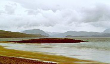
View of Loch Lomond looking north from Rowardennan.
Further Suggestions for Walks near Glasgow
- Arrochar Alps – a collection of mountains, including the Cobbler, overlooking the village of Arrochar and Loch Long.
- Balloch Country Park – a gentle walk on the eastern shores of Loch Lomond.
- Chatelherault Country Park – a gentle walk in a country park 2 miles south of Hamilton.
- Culzean Castle – a gentle walk through gardens, parkland and on clifftops overlooking the Firth of Clyde.
Accommodation
Plane Tree Cottage: 2 bedroom cottage situated on the shores of Loch Long at Arrochar, two miles from Loch Lomond and a 45 minute drive from Glasgow. For a brochure, contact Steve Minshull at plan…@currantbun.com
Transport
Station Taxis: taxi services to and from Glasgow Airport, Glasgow City Centre and Loch Lomond area. The company uses a wide variety of taxis, including cars and people-carriers, and they provide transport for the disabled. Telephone: 0141-942-4555


